Mental-Mapping Your City
This piece challenges the authority of data collected by the Internet of Things (IOT) in modern society. It evokes the personal narratives that urban inhabitants form as they move through the city, focusing on the depth and intensity of their relationship with their surroundings along the daily commute and the embedded values therein. By using only the body to power the mechanics of mapping, the rider re-establishes their relationship with the commuting experience. The analog records document sentimental interactions with our city and reclaim ownership of our stories in sound.


CHALLENGE
Efficient and exciting alternative possibilities can be embedded within the city’s transit infrastructure
Chicago is a heavily populated city and is continuously growing. In order to accommodate this growth, we must redefine idle spaces such as the space underneath elevated railways, tunnels and highway ramp, etc.
Why addressing the issue of idle spaces is important?
I think the idle spaces in the city segregate communities and jeopardize the harmonious coexistence between people and their environments just like highways do.

Cross Bronx Expressway
APPROACH
“A conviviality society means autonomous and creative interact among persons, and the interact of person with their environment.” —Ivan Illich
Our imaginations have been industrially conditioned to conceive only what can be molded into an engineered system of social habits that fit the logic of large-scale production.
PICKING UP THE PIECES
In my view of the phenomena related to city planning, the most unpredictable factor is the “mental value” of a city to its inhabitants, by which I mean how the individual personally interacts with and understands the public infrastructure. by which I mean how the individual personally interacts with and understands the public infrastructure.

CASE STUDY
How city inhabitants interact with their city’s infrastructures?
The trolley pusher in Manila, Philippines. The individual pushes their apparatus on segments of railways to earn money from passengers for daily expenses. They must know all the train schedules to avoid fatal impacts from any on-coming locomotives. They are not just dodging traffic, but also death. Why take such high risks to work and live alongside the railways? Areas adjacent to train tracks are usually neglected by developers, and they are where the poorest inhabitants gather in Manila. The pushers believe they can get mediate poverty by using existing public infrastructure themselves.
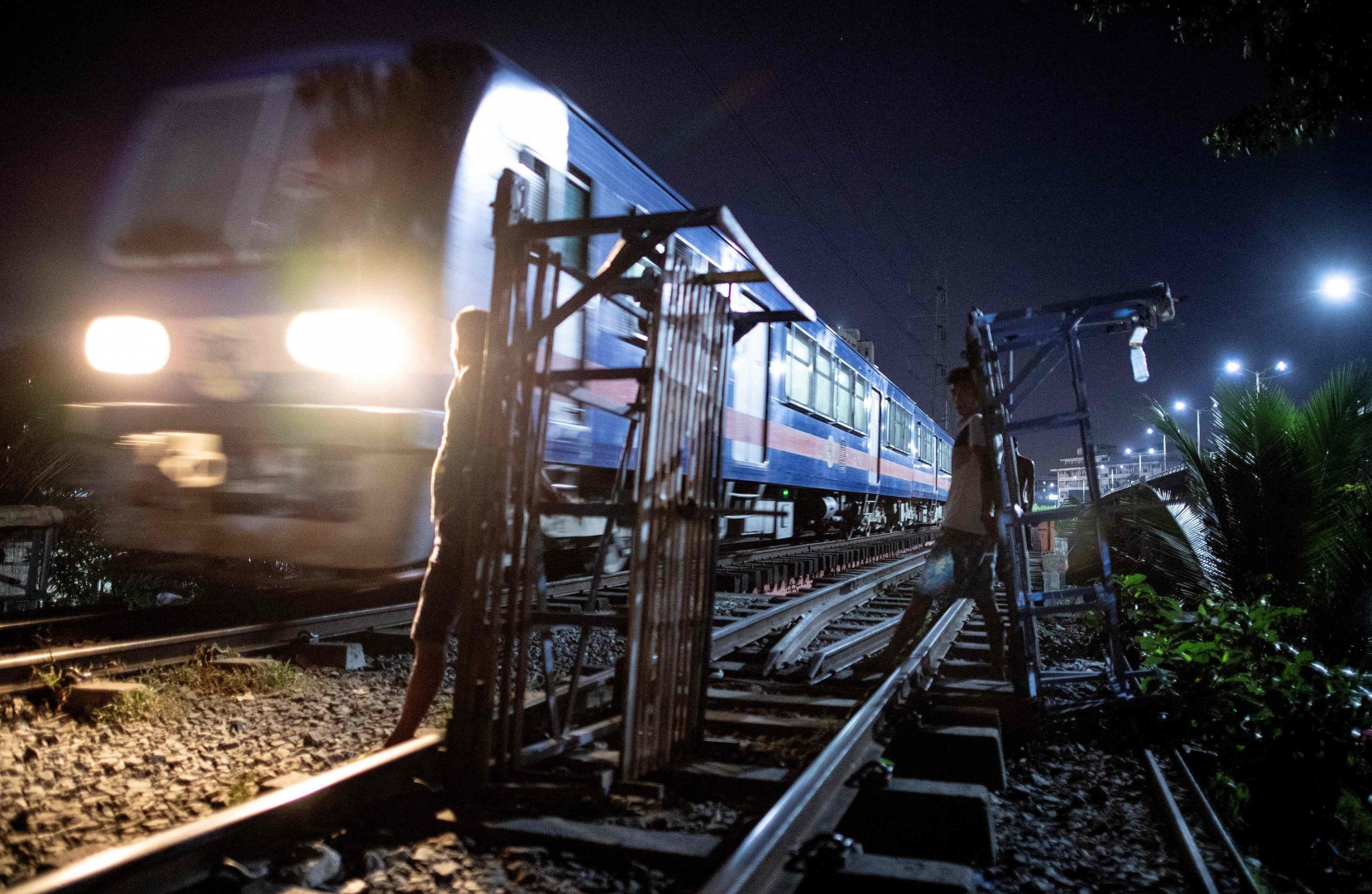

Trolly pusher, Manila
In Chicago, Jack Meyer has assigned mental value to a space adjacent to the CTA Red Line tracks. Meyer owns a property below the elevated Red Line tracks in the Boystown neighborhood. The site, a byproduct of public infrastructure, had been a graveyard for abandoned cars. When the CTA offered use of the site, Meyer jumped at the opportunity. He has turned it into an outdoor lounge where he and his friends drink coffee in the morning, cocktails in the evening. Occasionally he has friends over for barbecues and parties, but the ambient noise limits conversation. “Sunday is best because there are the fewest trains,” he says.
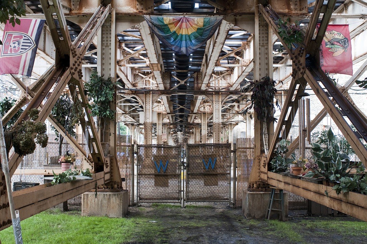
Grassy oasis beneath the Red Line tracks in Boystown
VISION
“It is important that these urban elements are not hermetically designed into precise and final detail but present an open-ended order. Urban inhabitants should be able to actively form their own stories and create new activities.” —Kevin Lynch
In each of the two cases, the inhabitant’s mental value of public infrastructures seamlessly coordinates with and improves the dynamics of city planning, beyond the data collected by IoT sensors. So, I wanted to design a machine that would enable me to generate my own mental values of my commute in the city and, at the same time, reclaim my authorship as an inhabitant and diminish the sense of alienation brought on by technology.
RETHINK
The quantitative data about human behaviors that IoT sensors collect does not capture the sense of sincerity, exclusivity, or ownership that may motivate atypical behaviors.
New technologies are invented to provide improved solutions for city planning. Thus, the Internet of Things (IOT) has become a popular technology, set to be an answer for better urban planning. The benefits are clear: how it enables prompt and efficient innovation in product design; how it lessens the need for real-world, physical effort; and how it is, in a way, its own reward—the more it is used, the better it becomes.
I even believe it’s a bonus for the ways we compose our surroundings. Still, I often feel left out – it’s rather an emotion than a fact. Are these raw data still mine? Or are they merely a result of this new technology? I want to reclaim my authorship, to reduce this sense of alienation.
BACKWARDS FOR WIDE VIEW
I am a designer and I want to provide an object in such a way that it gives room for three related ‘movements’: mapping, learning, shaping. First, people should be able to acquire a genuine mental map of their urban environment. Second, people should be able to learn how to navigate in this environment by training. Third, people must be able to operate and act upon their environment.
A legible mental map gives people an important sense of emotional security, it is the framework for communication and conceptual organization, and heightens the depth and intensity of everyday human experience.

FROM INACCURATE TO PRECISE
A Better Understanding of Mapping
Polynesian stick charts are a recording of information exclusive to the user. Navigators made the charts from thin strips of coconuts or pandanus root. They depicted sea currents around the shape of coast lines in geometric patterns. An interesting part of the charts is that they shift and translate so much information into their physical structure that they are meaningful only to the particular navigators who built them.

Polynesian Sticks Charts
These recordings were not made for navigation but for storytelling. Their tactile visualization enabled the Inuit to sequentially describe and subsequently recognize the contours, islands, and glaciers of the coastline. The gaps and shapes represented the conditions of the harsh environment such as brash ice and violent storm.

Tactile Visualization Wood
Such techniques were simple but carried surprisingly strong significance, formed by their makers. Hence, I decided to subvert the contemporary idea of technology by using the human body to power a bicycle that, in turn, captures my mental value of the city of Chicago through audio recording. The outcome is an intimate description of the surroundings and my own physical conditions.
FROM AMBIGUOUS TO OBVIOUS
I designed the machine to challenge the authority of data collected by IoT in modern society. It evokes the personal narratives that urban inhabitants form as they move through the city, focusing on the depth and intensity of their relationship with their surroundings along the daily commute and the mental value thereof. We can trace throughout the past various methods that humans have invented to record their surroundings. The fidelity of those methods’ outcomes—“recordings”—were not restricted to the capabilities of technology. Rather, recordings were primarily a tool for people to re-form their relation to their surroundings. In the same way, I wanted my project not to be limited by the capabilities of technology, but to connect the action to the final purpose.


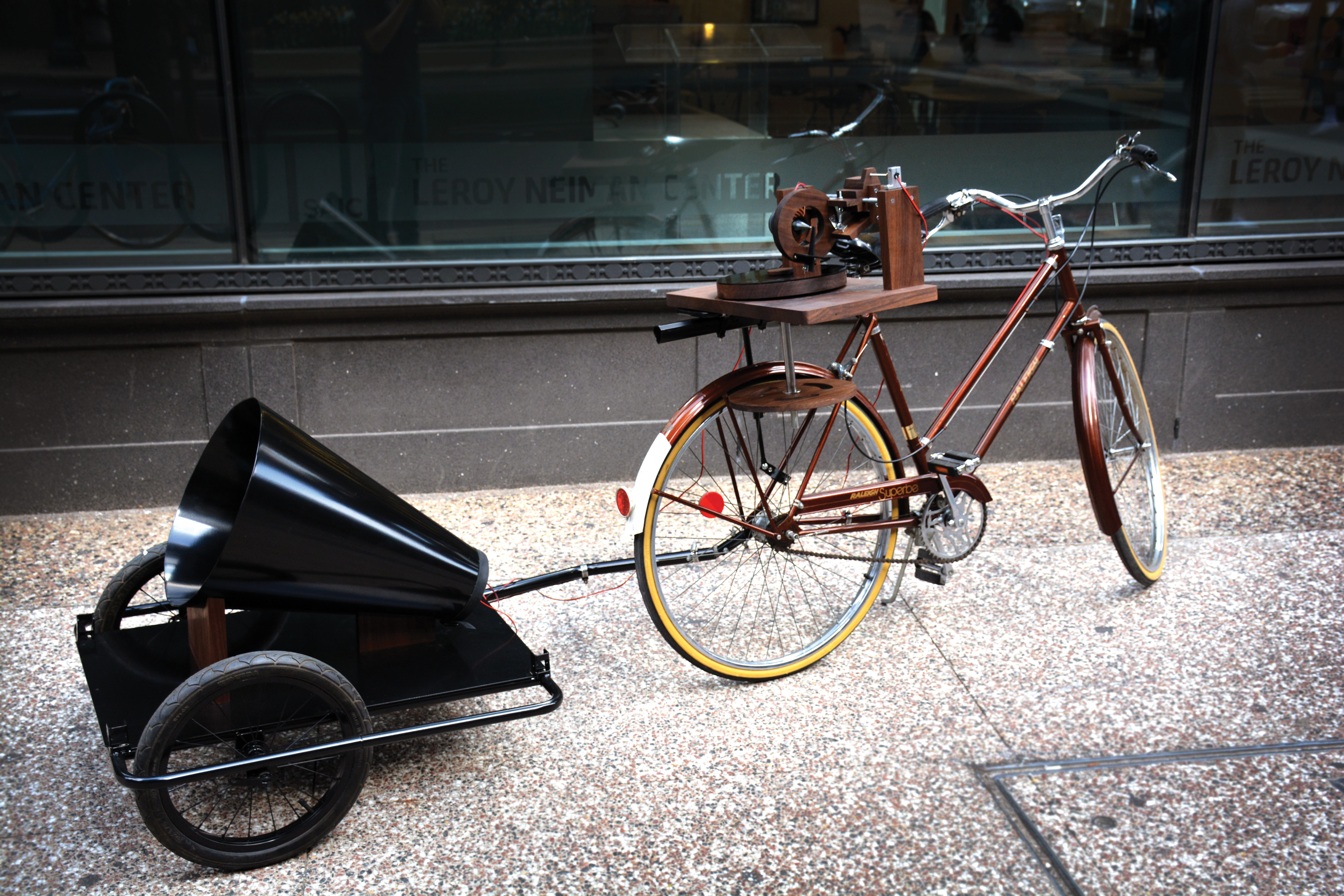
DETAILED DESIGN
Why Analog?
Why analog recording in sound? In addition to documenting the user’s direct interaction with the city, it allows the user to reclaim ownership of their story through the capture of sound. From the principle of the gramophone, the horn collects ambient noises, and then translates the uneven air currents’ impact onto thin film at the base. Once the film’s oscillations occur in multiple frequencies, the contact phone converts the oscillations into electrical currents and activates the stylus, engraving the spiral grooves on a blank record. The analog recording process, like the mental value of public infrastructures, is the direct result of personal, physical interaction with the urban space. It becomes a metaphor for the user’s hand writing their story—the stylus is a pen, grooves the ink, and blank records are the paper.
IMPACT
Induced Demand
By using only the body to power the mechanics of mapping, the user can re-establish their relationship with the commuting experience. Biking in the city of Chicago allows inhabitants to capture the most honest and dynamic moments of every corner and distinctive neighborhood they pass through in the city. The records are exclusive to their makers, and yet sharable with others to whom the makers might wish to tell their stories. In city planning, the value of IoT sensor data is unmistakable and increasingly significant; but the machine emphasizes the importance of the personal interactions that define people’s mental value of the place they live.

SAIC (School of the Art Institute of Chicago) DESIGN SHOW 2019
RESOURCES:
“Manila's 'Trolley Boys'.” BBC News, BBC
Bauer, Andrea. “A Grassy Oasis beneath the Red Line Tracks in Boystown.” Chicago Reader Polynesian Stick Charts
“Tactile Visualisations: Inuit Wood Maps.” Visualising Data
MORE PROJECTS
︎
︎